Friday, January 31, 2014

OSA and Killarney Lake Canoe Trip Sept. 2012

Day 1: Ottawa to Killarney Drive

What else to say: It takes the majority of a day to drive from Ottawa to Killarney (> 600km). We arrived in the evening at the Roche Rouge campground. The campground is located right at the Georgian Bay and quite scenic. 
Georgian Bay Scene: Pink Granite Beach

 Afterwards we made it to dinner at the Killarney harbour.
Trip Map
Above is the map of the entire canoe trip we did.


Day 2: George Lake to OSA Lake

We rented our Canoes at Killarney Outfitters. The canoes were in top-notch condition (light-weight and very comfortable on our shoulders to portage). We launched at George Lake.
George Lake Start and End Point
 The weather was beautiful and the scenery right after the start even better.
First Trip Impressions on George Lake: Huge pink Granite Rocks
After some easy portages we arrived mid-afternoon at OSA Lake and looked for a campground. We ended up at the northern side of the lake. While not its nicest it did have a definite advantage the next day. OSA Lake is exciting. It was the first lake I ever saw in Canada with crystal clear water. When paddling across it one can see the ground 10m lower (or whatever the depth was) without problems. Next time I bring diving goggles along.


Day 3: Hiking and Canoeing to Muriel Lake

In the morning we hiked up to the top of a Quartzite Hill on the northern side of OSA Lake right from our camp-ground. The views from above were simply stunning.
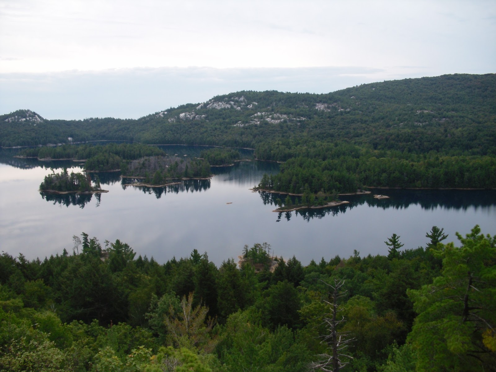
OSA Lake: View from one of its Northern Hills
The hike up requires good shoes. Afterwards we paddled further to Muriel Lake (one portage and some minor paddling). I only managed a 1-day permit on OSA despite booking off-season post Labor day. Muriel is a nice lake for swimming while not as scenic as OSA. The campground was decent.
Morning Impression on Muriel Lake


3. Day: Paddling back to Killarney Lake 

We paddled back to Killarney Lake via OSA Lake. On OSA we had a lengthy swimming break. Swimming and jumping from a rock into the crystal clear water was simply gorgeous.
OSA Lake: View towards its Northern Quartzite Hills. We went up on the one in the middle of the Picture a Day earlier.
OSA Lake: Swimming in its crystal clear Waters
The weather was again very good. Killarney Lake is as scenic as OSA Lake.


4. Day: Trip to the Crack and paddling back to George Lake

Killarney Lake morning Impression.
Above a morning impression from our campground at Killarney Lake (no wind yet). After we started paddling back towards the Freeland Lake portage it became quite windy.
Killarney Lake: Some of its northern Quartzite Hills in the Background.
Before portaging to Freeland Lake we stopped at a portage trail towards Kakakise Lake and headed up to "The Crack". This side trip was definitely worthwhile (again it requires sturdy shoes). I let the pictures speak for themselves.
Last Stretch towards "The Crack"
View from "The Crack". Killarney Lake in the front and OSA Lake in the back.
"The Crack" itself was surprisingly crowded (with people hiking in from the border of the provincial park). Given the views from the top this is understandable.
George Lake Wind Funnel at the portage to/from Freeland Lake. The wind blowed heavy.
We faced serious head-winds on George Lake and Freeland Lake on our way back. George Lake is like a massive jet funnel with rockwalls on both sides guiding the wind towards the George Lake Freeland Lake portage. We had to rope 2 of the 3 canoes together because myself and the kids weren't strong enough and not balanced properly to paddle against the head-wind (the various guides did warn about the possibility of strong wind on George Lake).

We made it back.

But everyone made it back and was happy. Paddling in Killarney is terrific. The scenery, the hills with their different rock types, the diversity of lakes (crystal clear ones and lakes with lots of plants and bogs) and the wildlife (we saw water snakes, big snapping turtles, vultures) was simply superb.

We made it back to Ottawa several hours after mid-night.

Saturday, January 11, 2014

Lake Louise and Moraine Hikes 2012

Day 14

Lake Louise and Moraine Trail Map


Lake Louise and 6th-Glacier Tea House

We went with the Greyhound bus to Lake Louise Village. We hiked up the tramway to the hotel and to the lake. The lake without the hotel is gorgeous (no doubt). There are also an awful lot of people.
Lake Louise and Mt. Victoria
Lake Louise
We decided to hike towards the end of the lake and go up to the 6-Glacier tea house. The path took longer then thought but nothing compared to the Assiniboine area.
Lake Louise, view towards the (ugly) Chateau
Even at the tea house there were relatively speaking lots of people. We had a good view towards Mount Lefroy and Mount Victoria and their respective glaciers. We also had a good meal at the tea house.
 Margaret went all the way up to the 6-Glacier view point.

Mt. Lefroy

Mt. Lefroy

Death Trap between Mt. Lefroy and Mt. Victoria

Afterwards we returned the same way. In the Lake Louise Village we had a meal and then waited very long for the return bus (it was running very late). Elevation: 700m and about 6h of hiking.

Day 15

Lake Moraine

We went again with the Greyhound bus to Lake Louise Village and then took a local shuttle to Lake Moraine. Lake Moraine and the 10 peaks are gorgeous as well.
Wenkchema Peaks and Lake Moraine

Lake Moraine
Again there were a lot of people. We decided to simply hike towards the end of the lake (going up to Larch Valley and the Sentinel pass was not possible because the Grizzly risk required parties of minimum 4 people). The hike to the end of the lake was easy. On the way back we considered briefly renting a canoe but the folks wanted an arm and a leg for 1h of paddling. It wasn't worth it. We had again a very good meal in Lake Louise Village because the bus was running late (the 4pm bus had a mechanical breakdown). Once we arrived in Banff we decided to have a 2nd meal of the day in Seoul Country House. The cold noodle soup was worth it. Elevation: 0m and about 2h of hiking.

Day 16

Margaret spend most of the day in Banff looking at various shops.

Banff, Banff Avenue
I spent most of the day reading at the train station after lunch (again cold noodle soup). Before lunch I visited the Vermillon rapids and the Cascade gardens. At 5pm we took the bus to Calgary starting our way back. We had another good meal in a Calgary "Milestone" restaurant.

Day 17 and Day 18

All of the time was spend in the bus and various Hamburger and/or Tim Horten places. I greatly enjoyed again the Lake Superior area. It is now on my list of future places to go.


Backcountry hiking in Banff and Assiniboine Parks 2012

Banff Hiking Trip July/Aug. 2012. M. and M. Wollensak

Day -2 and -1

We spend all the time in the Greyhound bus and various Hamburger and Tim Horten's places along the way. I liked the Lake Superior area and the North Channel area on Lake Huron. Also a number of prairie towns outside of Winnipeg and around Regina looked very appealing (space, clean, nice gardens and active agriculture). It was too dark to form an opinion about Kenora.

Day 0

Arrived in Banff with the Greyhound bus at about 11am. We immediately put up the tent in the municipal camping ground (it also has good showers). Afterwards we went to the Parks Canada Info center, finalized the trip and reserved the various camp grounds. Later we went to the Banff Hot Springs and soaked ourselves for about 2 to 3h. We had very good pizzas in the Bear Tavern.

Trail Map

Day 1

Castle Junction to Upper Twin Lake

Dropped by the Greyhound bus in the middle of nowhere (Castle Junction, basically a road crossing). Started from the parking lot. Within the first 100m encountered lots and lots of mosquitos. Killed up to 5 bugs with every swat of my hand. Halfway up Margaret decided to move ahead ... Finally I made it (with some help from Margaret). We were the only one's at the campground with Chelsey. Inside the tent was the only bug-free place. Upper Twin-Lake looked nice. 
Upper Twin Lake
Covered elevation: 700 to 800m. 9.4km distance. About 5 to 6h of hiking.

Day 2

Upper Twin Lake to Ball Pass Junction Campground

Started about 10am in the morning. First about 500m back to Lower Twin Lake. The lake looked beautiful (gorgeous waterfall into the middle of the lake). We should have spend more time there but did not because we thought we would see it plenty on the way up to Gibbon pass.
Reached Gibbon pass about 1.5 to 2h later. Still Mosquitos in the pass itself. The Larch trees towards the top are nice. The pass itself was reasonably open.
Gibbon Pass


Gibbon Pass
Continued all the way down to Shadow Lake Lodge (90min). It started to Rain when we arrived at the lodge. Margaret had a "tea" and meal there (supposedly was very good). The Lodge is at a nice place. After a longer break we decided to continue to Ball pass junction despite the clouds and the rainy circumstances. The weather improved soon after. Crossed a large creek flowing out of Shadow Lake. Shadow Lake looked very nice from the bridge over the creek. Mount Ball towered over it.
Shadow Lake, Mt. Ball in background
Finally arrived at the Ball Pass campground. Lots of mosquitos again. Margaret organized the tent inside (protected from Mosquitos) while I pumped the water and hung up the food. A thunder storm went through the area during the last day light but we were cozy in the tent and did not care. We were the only party at this campground. Covered elevation: 300 to 400m. Distance 12.1km. About 8h of hiking.

Day 3

Ball Pass Junction Campground to Egypt Lake Shelter via Whistling Pass

Started about 10am in the morning. Went up an initial step from the campground toward Hayduk Lake.
The flatish valley after the initial step was very very nice.
Whistling Valley, Whistling Pass in background
Haiduk Lake is at the end of the flat valley before the climb to whistling pass. The lake and a smaller 2nd lake are located very nice with Mount Haiduk rising right out of Haiduk lake. The 2 lakes are surrounded partially by alpine meadows. The pass is also visible at times. It was a nice day with good visibility at that time. At one place we encountered snow and fallen trees (leftover from an avalanche). After Haiduk lake the path climbed up to Whistling Pass. Partially steep, partially normal.
Haiduk Lake, Whistling Pass behind trees on the left
We first crossed the pine tree zone, then the larch tree zone, crossed a small meadow zone and finally entered a scree/stone zone towards the last 150m of elevation. The views from the meadow and scree zone back towards Mount Ball and Hayduk Lake were again very nice.
View back to Mt. Ball halfway up Whistling Pass
Finally we were up and had a view what was in front of us during the next days. Whistling Pass was BUG-FREE! We enjoyed staying up there for a while and looking back from where we came and towards where we were heading.
Whistling Pass, view toward Haiduk Lake and Mt. Ball
We also catched glimpses of Scarab and Mummy Lake from the pass. The weather was getting cloudy. We continued our trip. Initially the pass descended slowly but later it went down pretty steep for a much longer time then thought (and compared to Gibbon). About 100m above the valley ground it started to rain heavily. Margaret put on her rain gear. I opted to stay underneath large pine trees (was too lazy to get out my gear). Finally we reached the Egypt Lake shelter. Most of our shelter compatriots were already there. Needless to say that the shelter was mostly bug-free which was nice for a change. Elevation about 400m and 8h of hiking incl. breaks. Distance 9.1km.

Day 4

Egypt Lake Shelter (Rest Day)

Margaret decided to hike up to Scarab Lake. The lake was very nice.
Scarab Lake
She somehow missed the path to Mummy Lake however. I simply relaxed, washed and dried my salt-stained T-shirts and underwear and did a short hike to Egypt Lake. Egypt Lake is mostly surrounded by Forest.
Egypt Lake, Healy Pass meadows on picture right side

Day 5

Egypt Lake Shelter to Howard Douglas Lake Campground via Healy Pass, Simpson Pass, Wawa Ridge, Sunshine Village and Quartz Ridge

We started from the Shelter at about 9am. It was going to be a long day. We weren't 100% sure if we would make it. Going up to Healy Pass turned out a very pleasant hike. A lot of people in the shelter claimed coming down from Healy to Egypt Lake was a long slog but somehow for us the hike up was pleasant. Past the pine tree layer the larch tree layer was interspersed with meadows and towards to the top of the pass it was all meadows with lots of flowers.
Scarab Lake seen from 2/3 up to Healy Pass
The weather was beautiful. The flowers as well.

On top of the pass we had a view back to Mount Ball and Whistling and for the first time we could see Mount Assiniboine very far away indeed. Going down Healy Pass via the Monarch Ramparts through the meadows was lovely.
Healy Pass, Monarch Rampart Meadows below. Mt. Assiniboine just visible in the mist.
Healy Pass, Margaret and me. Mt. Assiniboine in the mist on the left (just the tip of its top)
We encountered very few bugs. Simpson pass was not far away (I somehow did not recognize it because it was the "lowest point"). But getting up to Wawa Rigde was a much longer affair then I thought. Even the "Calgary Mom's Club" from the Shelter catched up with me. But when I realized that I had mixed up Simpson and Wawa my mood was up because Sunshine Village wasn't far. We reached Sunshine Village at about 3:15pm. Now it was decision time. We decided to continue to Howard Douglas Lake. But first we enjoyed some Hamburgers and an "Alpine Plate" from the local BBQ operation. We also bought 2 sandwiches and the local anti-mosquito repellent (95% deed ...). At about 4:30pm we continued up the ski slope and then over the "Sunshine" alpine meadows towards Howard Douglas. Towards the end we had to go up and down Quartz Ridge before reaching Douglas Howard Lake. The campground was relatively crowded and full of mosquitos. Margaret immediatly vanished into the tent after it was up. I pumped the water. We decided to limit dinner to the sandwiches we bought earlier. None of us was in a mood to deal with the mosquitos. Elevation: 1200m and about 10h of hiking incl. breaks. Distance 17.9km.

Day 6

Howard Douglas Lake to Og Lake via Citadel Pass and Valley of the Rocks.

We started early. Had breakfast with people coming back from Magog. They advised us to refill our water bottles at the junction to Porcupine right before entering the valley of the rocks. That turned out to be good advice. We were relatively early on Citadel Pass (before noon).
View from Citadel Pass towards Mt. Assiniboine
It was an easy hike through alpine meadows. The day was nice. Citadel pass was bug free. We filled up the water bottles shortly after Citadel. Initially the path only descended slowly. But then it was a steep descend. Worst of all things the path was very very buggy. I was suddenly chased down by horse flies (they bit me). Once I catched up with Margaret I also used the "local" bug repellent. After going down about 400m the path went up and down about 150 to 200m above the Simpson valley ground for about 4km (no water). The weather was now gorgeous but also very hot. The path above the Simpson valley ground was very scenic.
Simpson Valley
We did fill up the bottles before entering the valley of the rocks. Going through the rocks valley was just another long stretch with some ups and downs. I had a break while Margaret went ahead. Finally Og Lake showed up. We build up the tent and had a meal at the common table. Og Lake was buggy again.
Og Lake, Mt. Assiniboine in the back
Elevation: 400m and about 9h of hiking including breaks. Distance: 16km.

Day 7

Og Lake to Lake Magog

This was a leisurely walk across meadows in open country. Mount Assiniboine came closer and closer. We ended up at the lodge first. Margaret wanted to know what a night there costed. Our pre-agreed limit was 100$ and less she could consider using for a night the lodge. It turned out to be a 260$ affair and on top of that they had no vacancies. The lodge is located at a gorgeous spot.
Mt. Assiniboine and Lake Magog view from the Lodge
We went further to the campground (buggy again) and build up the tent around early afternoon. I did a hike to the end of Lake Magog. Margaret decided to head over to Sunburn Lake and Cerulean Lake. Afterwards she went to the lodge for tea time (cakes and tea for 8$). Elevation: 50m and about 2h of hiking. Distance: 6.5km

Day 8

Lake Magog to Niblet, Nublet, Mount Nub and back

We did a hike to Mount Nub via Sunburst and Cerulean Lake. Margaret missed the junction to Niblet and headed to Lake Elizabeth. 200m on my way to the Niblet I heard a noise in bushes and saw something hairy and brownish. I decided not to look to closely and simply hiked on. I think it was the size of a smaller bear (but maybe it was something else). Margaret wasn't on Niblet. I was happy when she finally arrived (I was worried about her because of the bear). The view from Niblet was good.
Lake Magog and Sunburst from Niblet

Lake Magog, Sunburst and Cerulean from Niblet
Afterwards Margaret hiked up to Mount Nub while I hiked up to Nublet. The view from Nublet and Mount Nub was even better (photo country). All the lakes and Mount Assiniboine and the various glaciers were visible.
Lake Magog, Sunburst and Cerulean from Niblet

Ogg Lake and Rock Valley from Nublet
The lake Magog area is a dream.
Lake Magog, Sunburst, Cerulean and Elizabeth from Nublet

Lake Magog, Sunburst and Cerulean from Nublet
Afterwards we went together for tea time in the lodge. Margaret decided to pay the price for a shower/sauna in the lodge (20$). She was a decidedly happier camper afterwards. Elevation: 500m (Nublet), 700 (Mount Nub) and about 4h of hiking without backpacks.

Day 9

Lake Magog to Wonder Pass and back.

We hiked up to Wonder Pass which was a very leisurely walk without luggage through alpine meadows. Nog Lake was nice.
Nog Lake
At Wonder Pass we had a nice view over the whole Magog area and to Mount Nub.
Wonder Pass, view towards Nublet and Mt. Nub (picture middle)
We also had a reasonable view across Marvell Lake valley. It would have been the ideal path out of Magog. However it turned out that we could not arrange a pickup from the Mount Shark helicopter place because the flight schedule moved because of the upcoming long weekend. We had a another tea time in the lodge. Elevation: 250m and about 3h of hiking without backpacks.

Day 10

Lake Magog

It rained. We decided to stay one day longer. I did nothing. Margaret had a another tea time in the lodge. We had a conversation in the evening if we should consider flying out with the helicopter but ultimately decided to really hike out. We were getting somewhat tight with food items.

Day 11

Lake Magog to Porcupine Campground in the Simpson Valley

It was a gorgeous day.
Mt. Assiniboine

Lake Magog and Mt. Assiniboine closed to Camp Ground


We hiked all the way back to Porcupine campground. The campground was again buggy but nice. We had a short break at Og Lake. The path to the Simpson valley ground after the Rock Garden descended quite steep. I did the water pumping and cooking at the campground. Elevation: 100m during the up and down in the Rock Garden and about 8h of hiking incl. breaks. Distance: 15km

Day 12

Porcupine Campground to Sunshine Village via Citadel Pass and Quartz Ridge

We started early (8:30am). The sky was blue. The path to Citadel went steep upwards. Initially I walked in the morning shadaw. Unlike last time we weren't bothered by bugs and flies (I guess it was still to cold in the morning). After about 1h we were at the junction from Og Lake. After another 1h (and with some help from Margaret) the main ascent towards Citadel was behind us and we were in the larch zone. We were at Citadel Pass about 11:30am which was good. The pass was bug free and we had a break.
Citadel Pass, Margaret with Mt. Assiniboine right behind her

Citadel Pass, Margaret and me. Mt. Ball is the snowy mountain left
Afterwards Margaret hiked ahead towards Sunshine. We crossed again over gorgeous blooming alpine meadows towards Howard Douglas Lake.
On the way down from Citadel Pass towards Howard Dougles Lake. Mt. Ball in the background
The hike up Quartz Ridge was for me again hard work. I had a 30min rest about 50m elevation below the ridge. I was happy when I was up at the ridge. Another 2h hike from here through more meadows towards Sunshine village. I arrived at the village at about 2:50pm. I ordered a well deserved "Alpine Plate" from the BBQ guy.
Afterwards we had lemonade and a nep while waiting for the 5pm school bus which carried us to Banff.
We stayed overnight at the municipial Banff campground. The shower was gorgeous. Elevation: 750m and about 6:30h of hiking including breaks. Distance 13.8km.

One of the many mosquitos which did not make it ...

Day 13

I soaked up the whole day in the Banff upper sulphur hot springs. Margaret spent her time in the town. We dinned in the "Old Spaghetti Factory". See the next post for our comparatively easy hikes afterwards in the Lake Louise and Moraine areas.